Search
News

This year, the vernal equinox occurs on March 19, 2020. The last time it occurred this early was in 1896.
News

Climatologists from NOAA’s National Centers for Environmental Information (NCEI) compile the nation's climate "…
News

GOES-13 has served in the GOES East position since April 2010. Ten years ago today, on May 24, 2006, GOES-13 was launched…
News

While experts continue addressing an issue with the cooling system of GOES-17’s Advanced Baseline Imager (ABI), they have…
News
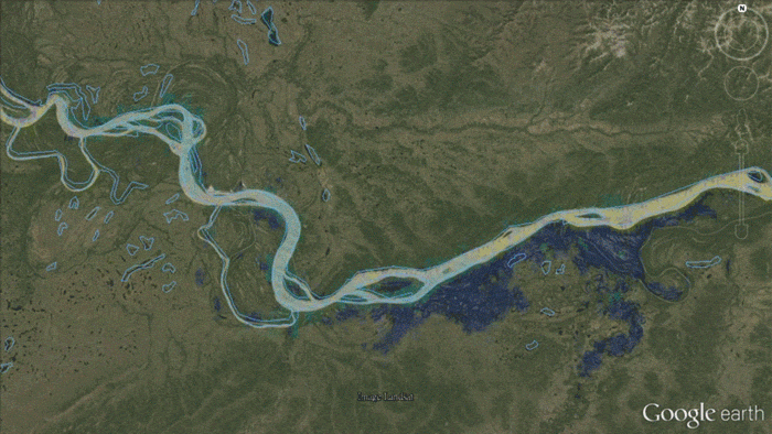
As part of the River Ice and Flooding Initiative, NOAA scientists with the Joint Polar Satellite System are working with…
News

NOAA-20 satellite zoomed in on a strong sandstorm that began blowing large amounts of reddish dust from the Sahara Desert.
News

In September 2023, NOAA NCEI and ECCC published its first Prairies and High Plains Climate Bulletin.
News

This week, NOAA satellites monitored a large “kona low” storm system that on Saturday began drenching Hawaii with heavy…
News

Every year at midnight on December 31st, the mathematical and mysterious converge as we witness a new year begin! It’s a…
News

This week, NOAA will begin releasing GOES-17 Advanced Baseline Imager (ABI) “beta” level data and imagery.
News
This new imagery shows data are currently available from all 16 ABI channels.
News

The severe storms that brought tornadoes, damaging winds, rain, and hail to the Southeast over the weekend, leaving tens…
News

Satellites are a valuable tool for monitoring Earth’s oceans, which cover more than 70 percent of our planet. This…
News

The new marine heat wave off the Pacific Coast is reminiscent of the early stages of the 2014–2016 “blob” that devastated…
News

NOAA satellites see our planet from a unique and captivating perspective. Every year, our satellites see the beauty and…