Search
News

Hurricane Katrina imagery from GOES East including rapid scan data from August 22 through September 1, 2005.
News

We’ve seen tropical cyclone activity in the Atlantic basin heat up quite a bit—most notably with the landfall of Hurricane…
News

Early in the morning on October 25, 2012, the Suomi NPP satellite passed over Hurricane Sandy after it made landfall over…
News
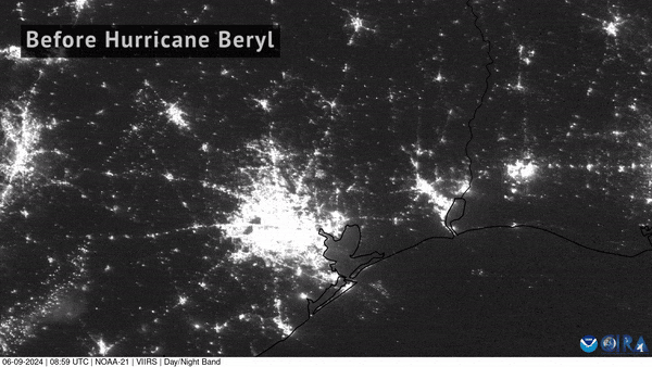
NOAA-21 captured imagery of the devastating power loss across East Texas following Hurricane Beryl’s landfall.
News

Sept. 10 marked the peak of the Atlantic hurricane season, which officially runs from June 1 through Nov. 30.
News

At least nine people died from torrential rains in New York and New Jersey as Hurricane Ida moved North.
News

The ability to use satellites to locate a storm that could evolve into a severe storm, or hurricane,.
News
October 08, 2020 Between October 1 and October 3, 2020, Hurricane Marie was tracked by Canada’s RADARSAT-2 satellite in the…
News

This before-and-after imagery from GOES East shows a changed landscape and flooding after Hurricane Florence affected…
News

The 2021 Atlantic Hurricane Season officially came to a close on Nov. 30, and was the third-busiest Atlantic season on…
News

In 2004, the Atlantic had one of its most active and destructive hurricane seasons on record. These storms produced more…
News

On the morning of August 30, 2023, at approximately 7:45 a.m. EDT, Hurricane Idalia made landfall near Keaton Beach, Florida…
News

In the late evening hours of August 17, 1969, a catastrophic storm named Hurricane Camille slammed into the Gulf Coast. A…
News

Although not yet operational, data from NOAA’s GOES-16 satellite proved vital in forecasting operations for Hurricane Maria…
News

NOAA satellites have tracked a lot of activity across western North America this month. From wildfires, to a hurricane, to…