Phenomena: Wildfires, Pyrocumulus, Smoke
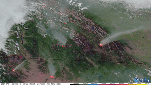
Satellite: GOES-18
Product: GeoColor, Fire Temperature
Instrument: ABI
Date/Time: July 24, 2024 – July 25, 2024
A high resolution view from NOAA’s GOES West (GOES-18) satellite shows wildfires raging across the Pacific Northwest. The 2023/2024 winter season was the warmest on record for Canada and continuing drought conditions led to an early start of the wildfire season for the western part of the country.
The first major fire started on May 10th, 2024 near the remote town of Fort Nelson in British Columbia. Dry and windy conditions quickly spread the fire to over 13,050 acres in just three days. On July 22nd, a fire started near the Jasper National Park, which prompted evacuations of the park and the nearby town of Jasper.
The GOES West satellite, also known as GOES-18, provides geostationary satellite coverage of the Western Hemisphere, including the United States, the Pacific Ocean, Alaska and Hawaii. First launched in March 2018, the satellite became fully operational in February 2019.