
Near real-time preliminary data from NOAA’s first Compact Coronagraph (CCOR-1), a powerful solar telescope onboard the GOES-19 satellite, are now publicly accessible. GOES-19, launched in June 2024, began providing the new data through the Space Weather Prediction Center (SWPC) website as of February 25, 2025, and from the National Centers for Environmental Information (NCEI) archive starting March 7, 2025.
CCOR-1 was designed to continuously monitor the faint outermost layer of the sun’s atmosphere, called the corona, to detect large, fast-moving plasma eruptions called coronal mass ejections (CMEs). As the first modern coronagraph for space weather forecasting, CCOR-1 will provide the primary observations used to predict impending geomagnetic storm conditions, allowing SWPC to issue improved watches and warnings one to three days in advance. This gives operators critical lead time to take precautionary actions to protect vital infrastructure, economic interests and national security.
Space weather events like CMEs can disrupt power grids, satellite operations, radio communications, and GPS navigation. Forecasts based on CCOR-1 images are critical for power grid managers so they can take preventive measures to ensure that power flows smoothly and to prevent transformer failures. Additionally, SWPC uses CCOR-1 data and imagery to develop watches and warnings that are invaluable to industries ranging from commercial aviation to precision agriculture, oil and gas exploration, and even national defense among others.
Thus, the CCOR-1 instrument is an important provider of data to ensure these critical systems are protected from severe space weather events.
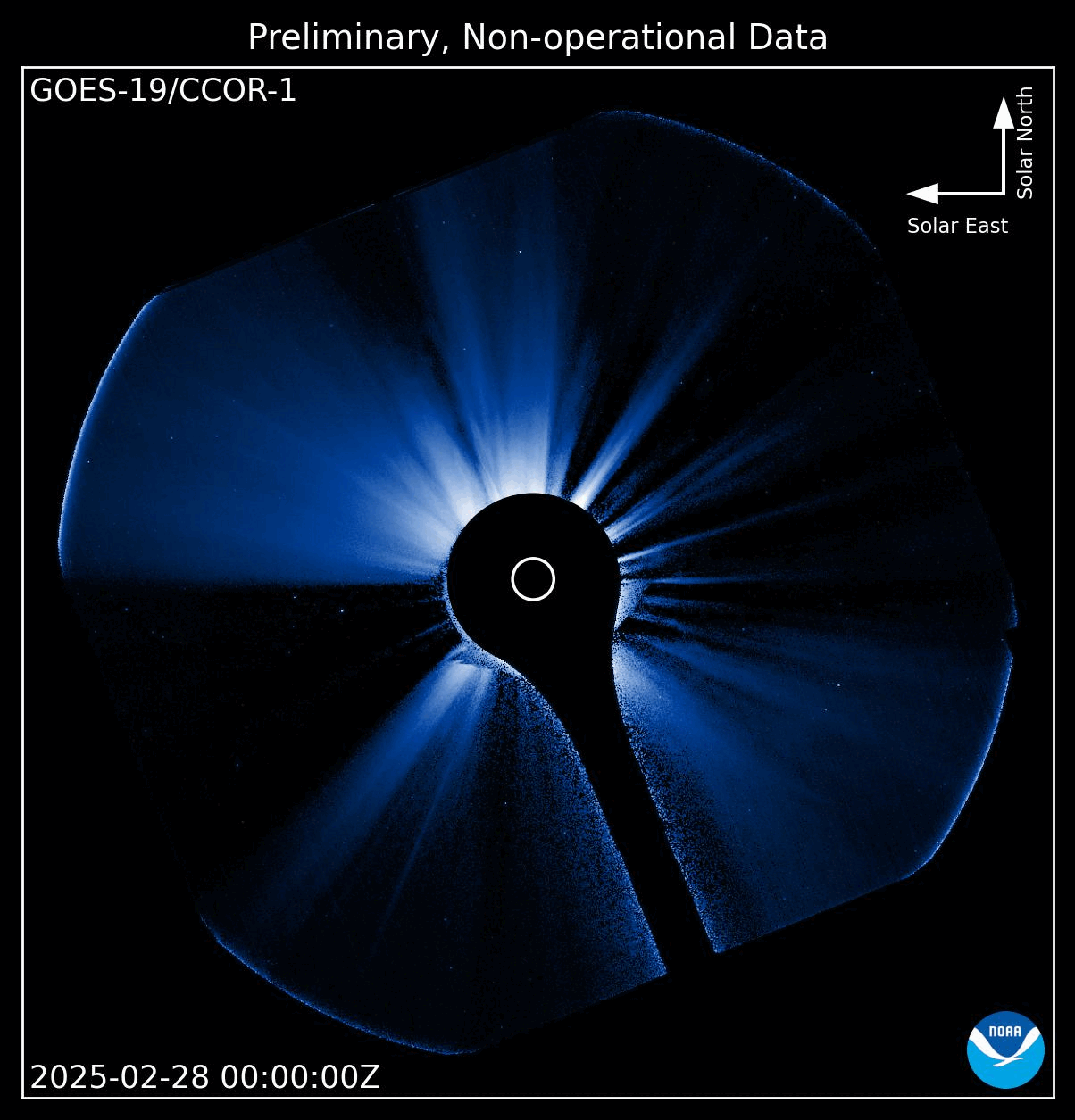
The video above, captured by CCOR-1, shows the sun’s corona. The sun’s size is indicated by the small empty circle, and the instrument blocks most of the sun’s light using a dark disk that is almost four times wider. This allows fainter structures, like CMEs, to be detected. CMEs are seen as bright wispy plasma clouds expanding away from the dark disk.
Twice a day, there is a flash due to the Earth “photobombing” the CCOR-1 field of view. The flash, or ‘earthshine’, is due to the strong reflection of sunlight from our oceans and clouds. Furthermore, the moon passes through the image approximately once a day and is brightly lit due to the same reflection off the planet’s surface.
CCOR-1 videos spanning the latest 24 hours of activity can be viewed anytime on the SWPC website.
CCOR-1’s data is delivered every 15 minutes, a significant improvement compared to the previous system which utilized the LASCO coronagraph, which often had delays of several hours. Since it was activated in September 2024, CCOR-1 has witnessed many space weather events, including the multiple CMEs that produced the powerful geomagnetic storm of October 10, 2024 and even images of comets, ranging from the luminous Tsuchinshan-ATLAS (C/2023 A3) to extremely faint objects.
GOES-19 will be assigned the operational role of NOAA's GOES East satellite on April 4, 2025. However, SWPC has already begun informally using CCOR-1 observations to inform and improve its space weather forecasts.
Meanwhile, a nearly identical coronagraph, CCOR-2, will be flown onboard NOAA's Space Weather Follow On - Lagrange 1 (SWFO-L1) mission which will operate closer to the sun at the sun-Earth Lagrange 1 point, approximately one million miles from Earth. Together the two instruments will provide resiliency of observations: if one were to fail, the other would continue to be accessible, ensuring continuous observations of the corona.
In addition to streaming the near-real-time images at SWPC, NOAA plans to archive images from CCOR-1 and CCOR-2 and make them available at NCEI’s space weather product page for SWFO, where researchers and citizen scientists alike will be able to search for, display, and download them.
NOTE: Until GOES-19 becomes operational, all CCOR-1 imagery and data remain preliminary and non-operational.