Photo courtesy of the Sterling, Va., NWS Forecast Office
Ten years ago this week, the Eastern U.S. was getting pounded by a brutal winter storm that brought blizzard conditions and record amounts of snowfall. Though heavy snow and high winds were seen from Indiana to New Jersey, as well as southward along the Appalachian spine,the storm is mainly remembered for hitting the Mid-Atlantic particularly hard.

Water vapor image via GOES-12 from Feb. 5, 2010. The red color signifies drier air.
Dubbed both “Snowmageddon” and “Snowpocalypse,” the storm was one for the history books. It dropped the heaviest single-storm snowfall ever recorded at Washington’s Dulles International Airport—a whopping 32.4 inches. It also produced the second-heaviest snowfall in Philadelphia (28.5 inches) and the fourth-heaviest at Washington’s Reagan National Airport (17.8 inches). Ten years later, those records still stand.
Back then, NOAA’s current generation of satellites—the Geostationary Operational Environmental Satellites-R (GOES-R) and Joint Polar Satellite System (JPSS) series—were still in development. When the first of these satellites, GOES-16, launched six years later, it started revolutionizing weather monitoring and forecasting. Now when monster snowstorms like Snowmageddon threaten the U.S., scientists and forecasters can track and predict them in unprecedented detail.
In 2010, NOAA’s legacy GOES satellites were watching the storm from its genesis over the Southwestern U.S. and Mexico. During the course of several days, it strengthened as it pushed northeastward across the Midwest and eventually, the East Coast.

Composite water vapor imagery loop via GOES-12 with cloud-to-ground lightning strikes.
This massive winter storm brought flooding and landslides to Mexico, drenching rain and thunderstorms across the Deep South, heavy snowfall to the southern Appalachians, and snowfall rates of one to three inches per hour in parts of the Mid-Atlantic. At one point, both near-blizzard and blizzard conditions (sustained winds of 35 mph; visibilities of ¼ mile or less) were reported across several states.

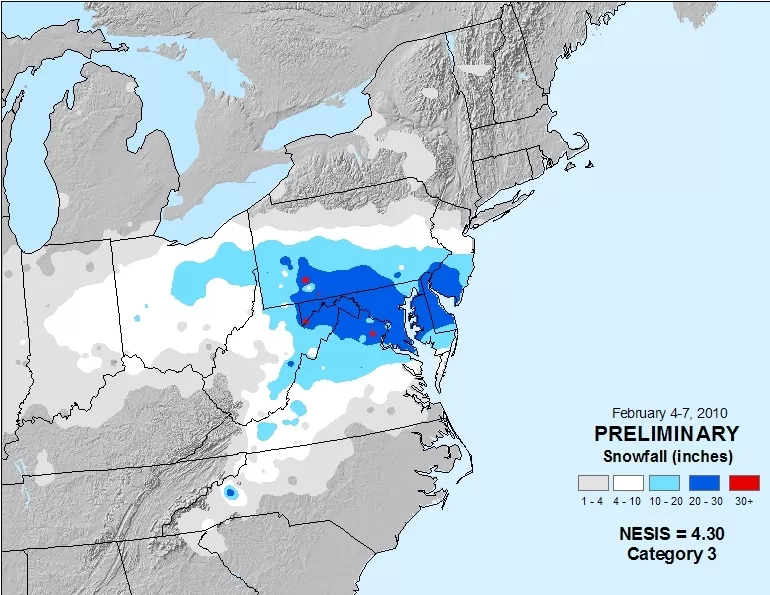
Preliminary snowfall analysis and Northeast Snowfall Impact Scale (NESIS) rating for "Snowmageddon."
But the biggest weather story was, of course, the snow—and lots of it. Four or more inches of snow stretched from Indiana to New Jersey, and southward through North Carolina. One-to-two feet of snow were common in southern Pennsylvania, southern New Jersey, Maryland, Delaware, and northern Virginia. Measureable snow fell as far north as New York and as far south as Georgia.

Today, NOAA’s latest generation of GOES satellites (GOES-16 and GOES-17) keeps constant watch over the contiguous United States, Alaska, and Hawaii, as well as the Atlantic and Pacific oceans. NOAA’s Joint Polar Satellite Series orbits the Earth 14 times a day, from pole to pole, and is the backbone of NOAA’s life-saving forecasts. With NOAA’s current fleet of satellites now providing state-of-the-art capabilities, forecasters are more than ready if—or when—Snowmageddon II roars to life.
