
Drought is a major threat to global food security, leading to reduced agricultural productivity, higher food prices, and disruptions in food distribution, exacerbating hunger and malnutrition. It also triggers secondary effects like insect outbreaks and wildfires, further harming crops. Economically, drought costs the U.S. around $9 billion annually, with insurance payouts for crop losses skyrocketing from $325.6 million in 1995 to $1.65 billion in 2020, a 400% increase. Climate change is expected to worsen this, with projections of a 12% global crop yield decline by 2050. In 2023, 238 million people faced acute food insecurity, a 10% rise from the previous year.
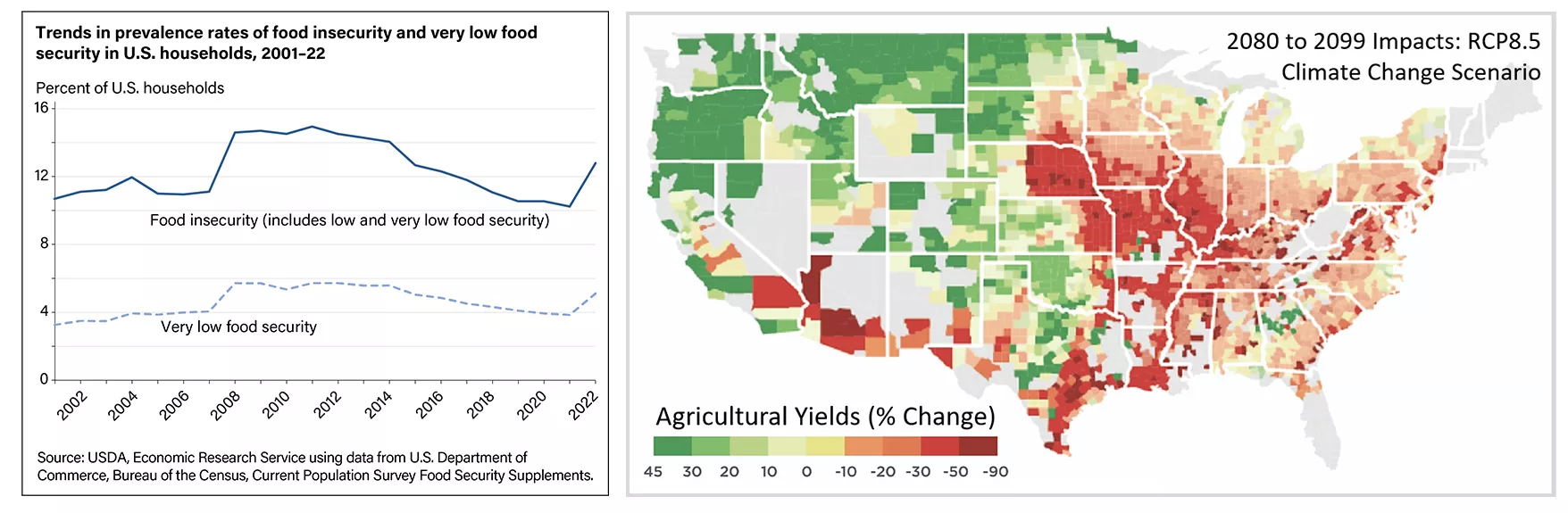
Left: In 2022, 17 million U.S. households (12.8 percent) were food insecure during the year, meaning they had difficulty providing enough food for all their members because of a lack of resources. Source: USDA Economic Research Service. Right: County-level median average impact for maize, wheat, and soybeans (percent change) for the period 2080 to 2099 in the RCP8.5 climate change scenario, the highest baseline emissions scenario in which emissions continue to rise throughout the twenty-first century. Source: Hsiang, S. et al. 2017.
To reduce the impact of drought on agriculture, the Joint Polar Satellite System (JPSS) missions are critical for crop monitoring and drought forecasting. NOAA’s Center for Satellite Applications and Research (STAR) uses data from the JPSS Visible Infrared Imaging Radiometer Suite (VIIRS) to generate global and regional vegetation health products, including detailed Vegetation Health Index (VHI) maps. These maps serve as proxy data for assessing vegetation stress, drought conditions, soil saturation, and the timing of growing seasons, among other factors crucial to agricultural productivity. By providing a more accurate and comprehensive view of global agricultural conditions, satellite-based vegetation health products help government agencies, farmers, and other stakeholders better anticipate and respond to drought conditions, ensuring more effective management of food production and bolstering global food security.

This global Vegetation Health Index (VHI) map (4-kilometer, 7-day composite) derived from the JPSS Visible Infrared Imaging Radiometer Suite (VIIRS) shows change in vegetation health from January 7, 2023 to September 16, 2023. Source: NOAA’s Centers for Satellite Applications and Research.
NOAA’s VHI maps play a pivotal role at the U.S. Department of Agriculture (USDA) World Agricultural Outlook Board (WAOB) by providing detailed insights into how crops are affected by temperature and weather extremes, which are used to forecast crop yields and inform the World Agricultural Supply and Demand Estimates (WASDE) report. Released monthly by the U.S. government, the WASDE report offers a comprehensive global overview of agricultural market conditions, including forecasts of crop production and supply. Various stakeholders—agribusinesses, commodity traders, food producers, retailers, consumers, and researchers—use the WASDE to make informed decisions based on global supply and demand.
“The VHI has been an integral part of our operations for 16 years and counting,” says Eric Luebehusen, a meteorologist with the USDA Office of the Chief Economist/WAOB. Each week, WAOB analysts use VHI maps to support the development of the WASDE report. The predictive power of VHI data helps stabilize agricultural markets by allowing stakeholders to anticipate and adapt to fluctuations in crop production caused by drought and other environmental stressors. Additionally, by examining historical VHI trends, experts can identify typical crop conditions and their variations, creating a baseline for regional crop health. This data is essential for predictive models that anticipate yield fluctuations, a key factor in reducing uncertainty in agricultural markets and ensuring food security.
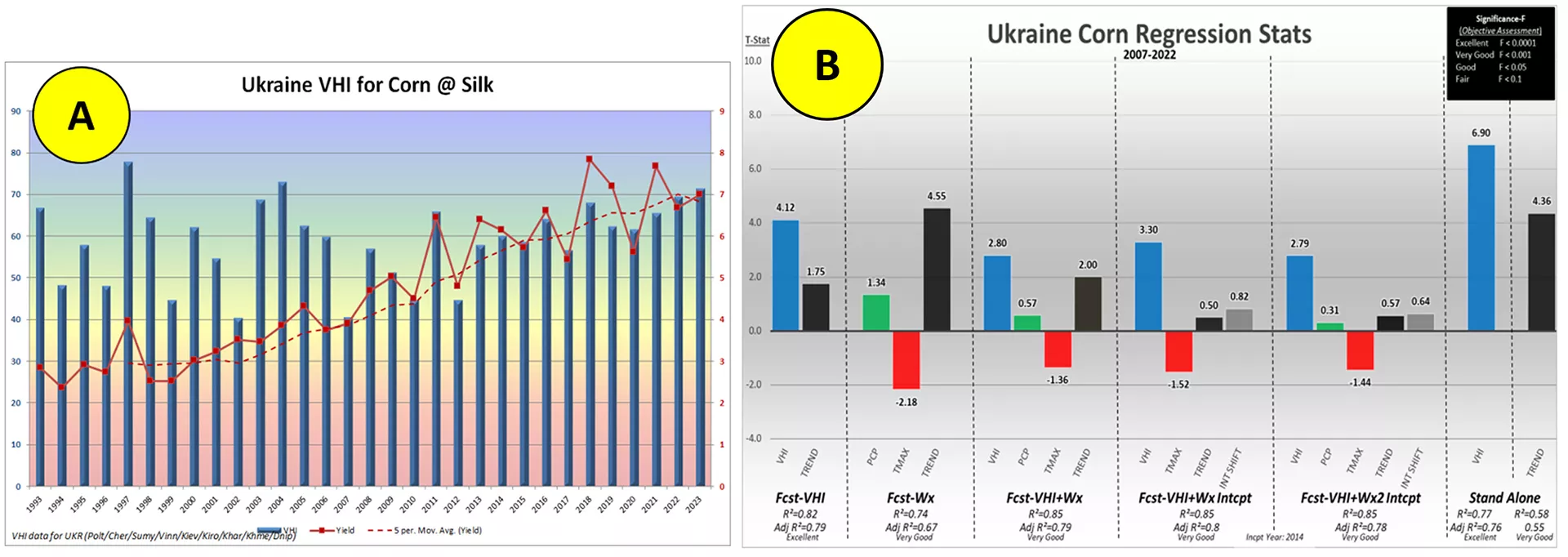
Example modeling performed by Leubehusen, a meteorologist at the USDA WAOB, in preparation for the WASDE report. Left (A): Yearly VHI (blue columns) and corn yield in the silk growth stage (red line) in Ukraine. Right (B): Regression model statistics for Ukraine corn yield that compares the performance of different VHI and weather (Wx) models.
As climate change continues to drive food insecurity for millions, satellite-based crop intelligence systems offer crucial support for improving food production and distribution efficiency. Vegetation health products, like those developed by NOAA STAR and used by the USDA, play a key role in maintaining global food security. Stay tuned for a deeper exploration into this topic in the upcoming 2024 LEO Science Digest, published in January. In the meantime, the 2023 Science Digest offers a range of articles highlighting the diverse applications of LEO satellite data beyond vegetation health.