
The Constellation Observing System for Meteorology, Ionosphere, and Climate (COSMIC-2) is a network of six small satellites, each about the size of a standard kitchen oven, designed to improve weather prediction and model accuracy as well as space weather monitoring capabilities.
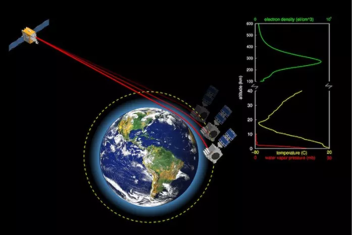
COSMIC-2 utilizes a technique called radio occultation to measure the "bending" of radio signals from global navigation satellites (such as GPS) as those signals pass through the Earth's atmosphere and ionosphere. This bending provides critical information such as the temperature, pressure, and water vapor content of the atmosphere, helping improve global forecasting and aid in studying Earth's climate. This also gives us better insight into the processes that cause tropical storms to develop, strengthen, or weaken. The same signals also give information about highly charged regions of the Ionosphere. This data is used to understand the effects and impacts of space weather, such as solar storms, on the Ionosphere and elements of daily life such as communications
Following launch on June 25, 2019, the satellites underwent an initial seven-month instrument and data evaluation process to make sure they were working properly as they were moved into their proper orbit. This was then followed by a period of software updates to enhance performance. During this time, a series of reviews were held to make sure that numerous specific milestones were being met by the spacecraft and the associated ground systems. These determined that:
- The six satellites were located where they were supposed to be in orbit
- The ground stations were functioning properly
- The data collected by the satellites was validated and correct
- The data processing centers in Taiwan and the U.S. were operational
- The backup ground station that has commanding capability will work in case the primary ground station cannot send signals to the satellites
- The data could be properly archived
On September 14 and 15, 2021 a board of scientists, engineers, and senior leadership from NOAA, USSF, UCAR, and NSPO held the Full Operational Capability (FOC) review, which verified that space weather data from COSMIC-2’s main instrument were properly calibrated and validated. This was the final major review remaining to achieve FOC status, and the review board praised the program and the team for a very detailed and meticulous presentation. Based on the recommendation of the review board, the COSMIC-2 Joint Mission Executive Steering Committee declared the mission achieved FOC with flying colors. We spoke with Wei Xia-Serafino (Program Manager) and William (Billy) Gullotta (Lead Systems Engineer), who moderated the meeting, to learn more. Below are their combined answers.
QUESTION: What does achieving FOC mean?
ANSWER: Since we passed the review, we’re declaring that COSMIC-2 is meeting or exceeding all of its mission objectives.
QUESTION: What happens now?
ANSWER: The team is currently working on further increases to the performance and capabilities of COSMIC-2’s payload instruments, as well as completing validation of measurements made by the secondary payload.
QUESTION: How much better does the data from COSMIC-2 improve our current forecast models?
ANSWER: COSMIC-2 contributes to a 6-8% error reduction of the total forecast improvement impact.
QUESTION: Can you tell us a little bit about what makes COSMIC-2 so special?
ANSWER: COSMIC-2 uses a technique called radio occultation (RO) to detect changes in signals from GPS satellites as they pass through the atmosphere. By studying these changes, COSMIC-2 can give us near real-time information about the Earth’s atmosphere including conditions such as temperature, pressure, density, and water vapor.
Additionally, COSMIC-2 has several capabilities not currently provided by other RO missions:
- High signal-to-noise ratio
COSMIC-2 radio occultation profiles are achieving the highest signal-to-noise ratio ever recorded for RO and can track signals lower into the troposphere than other similar missions. This is especially useful for helping us understand more about weather events in the tropics, such as tropical storms, tropical cyclone development, and more.
- Low latency
This basically means that compared to other RO missions, we can obtain data faster after making an observation than any other RO missions. The ability to obtain data this fast is particularly important for space weather applications at low latitudes. Current latency capabilities of commercial RO data providers do not meet our nation’s space weather needs.
- Full local time sampling
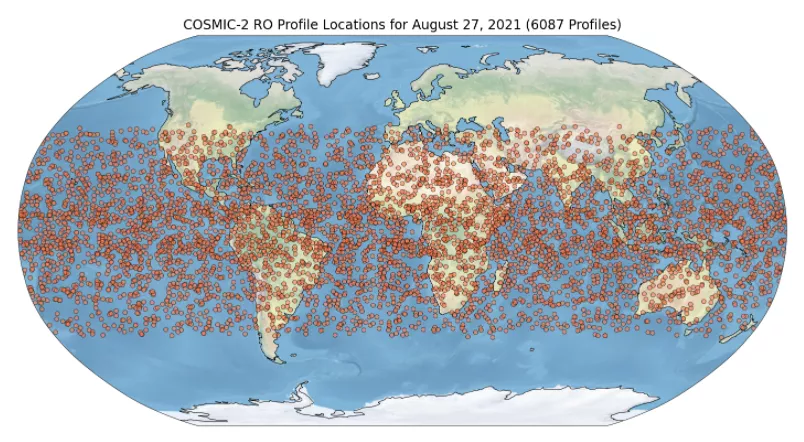
The six COSMIC-2 satellites are always orbiting equidistantly from each other in locations around the world. This enables the constellation to basically give us a really good picture of what’s going on around the entire globe at all times. I think we’re taking about 40 observations every 10 minutes based on current data. This minimizes spatial sampling errors and improves space weather and climate change studies.
- Full ionosphere profiling
Our fields of vision are, and therefore the measurements we take are located in the entire space below, above, and behind the spacecraft. This gives us insight to the ionosphere from 90 km above the Earth's surface all the way to directly above the spacecraft which is really important when monitoring the very dynamic changes in the ionosphere.
- Ionospheric Scintillation Detection and Localization
This one is really cool, and a unique part of COSMIC-2. Scintillation is essentially these fluctuations in radio frequency signals through the ionosphere due to disturbances in the structure of plasma, or ionized gas. This phenomena can cause interruptions of some communications and navigation systems. Since COSMIC-2 uses GPS signals to make measurements, we can measure the scintillation, or interference..
Before COSMIC-2, these measurements could only be made from ground-based stations. We can now measure this phenomena across the entire globe, over land and sea.Although we can’t really do anything about the effects of scintillation, being able to detect it allows us to understand where there may be interruptions in things like GPS. Observing scintillation is important for people who use information about radio signals to understand how to avoid it potentially, or to understand why they're seeing what they are seeing. It's a really new and emerging area in ionospheric physics and we were really quite lucky to be among the world leaders in making these scintillation measurements.
Although COSMIC-2 has achieved Full Operating Capability, work is ongoing and the team will continue to make upgrades to further improve the mission. For instance, they are developing new space weather products and are continuing to validate the science payloads onboard, both of which are space weather instruments. Another upcoming upgrade will add the ability to measure occultations from the European Union's Galileo GNSS constellation, allowing the mission to further increase their RO output. COSMIC-2 will continue to deliver high quality neutral atmosphere and space weather observations to improve weather prediction, space weather monitoring, and accuracy of weather forecasting models throughout the end of its mission.
**The COSMIC-2 satellites are owned and operated by the Taiwan authorities, but the mission is a joint collaboration between NOAA, the U.S. Air Force, U.S. Space Force, Taiwan’s National Space Organization (NSPO), and the University Corporation for Atmospheric Research. In Taiwan, the mission is known as FORMOSAT-7.