
October 01, 2020
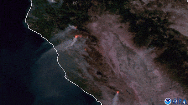
On September 27, 2020, NOAA’s GOES-West satellite continued watching the spate of wildfires that are engulfing the West Coast. These particular clusters, the August Complex fire in the middle and Glass fire near the bottom, are in California and were viewed using a combination of GeoColor and Fire Temperature products.
In particular, the August Complex’s persistence over the past 45 days has been aggravated by the excessive heat , low humidity , and high winds that are currently affecting much of the West Coast. According to NOAA’s Weather Prediction Center , “Air Quality Alerts remain in place over portions of the West Coast and central High Plains due to ongoing bouts with wildfire smoke,” which is clearly visible from our satellites in outer space.
This GeoColor enhanced imagery was created by NOAA's partners at the Cooperative Institute for Research in the Atmosphere. The GOES-West satellite, also known as GOES-17, provides geostationary satellite coverage of the Western Hemisphere, including the United States, the Pacific Ocean, Alaska, and Hawaii. First launched in March 2018, the satellite became fully operational in February 2019.