
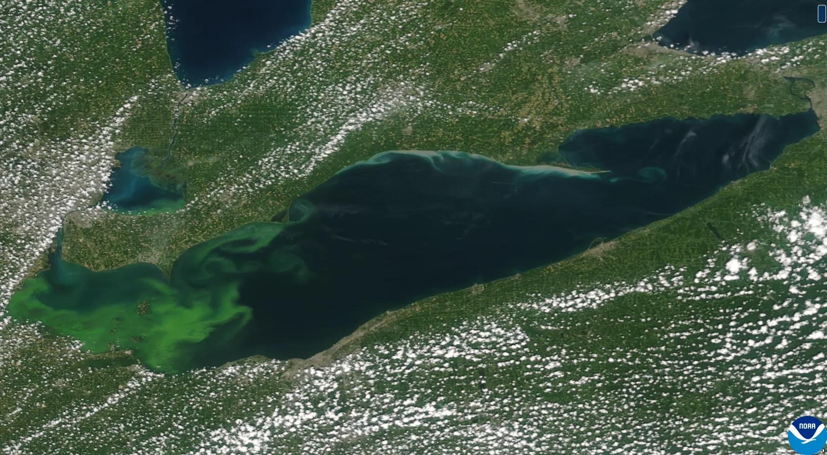
Image of a harmful algal bloom in Lake Erie as seen from the NOAA/NASA Suomi-NPP satellite on August 16, 2015. The Ocean Color Instrument on GeoXO will overcome the limitations of low-Earth orbiting satellites whose observations are often affected by cloud cover and sunglint. [Credit: NOAA]
After nearly 50 years of GOES satellites providing critical Earth-observing data and imagery, NOAA is working on its next generation series of advanced geostationary satellites—the Geostationary Extended Observations mission, or GeoXO.
GeoXO will host a payload of new instruments that will provide unprecedented information for addressing our changing planet and the evolving needs of NOAA’s data users.
One of those instruments being developed by BAE Systems is the Ocean Color Instrument (OCX), which will provide fine-scale data about the U.S. coastal waters and the Great Lakes from geostationary orbit.
Current ocean color instruments on NOAA’s polar-orbiting satellites orbit around certain areas only once or twice a day. This makes them especially vulnerable to passing over a water body that is shrouded in clouds or reflecting “sun glint,” both of which can obscure the data the satellites receive.
Geostationary satellites, however, orbit at the same speed that the planet rotates—allowing them to hover over the same part of the globe constantly. Not only does this reduce the cloud cover and sunglint issue, it allows them to continuously monitor a specific area to track both short-term and longer-term ocean and coastal ecosystem changes.
“I always thought geostationary remote sensing makes a lot of sense,” said Jack Pan, Founder of Ocean Motion Technologies, which focuses on marine hydrokinetic energy for small-scale applications. “OCX will provide us with near real-time, high-resolution data that is essential for monitoring ocean conditions and making informed decisions that benefit our clients in ocean science and conservation.”
This more frequent and finer-scale data will be a game changer compared to the current measurements from polar-orbiting satellites. In fact, OCX will provide updated ocean and lake data at least every three hours, which is critical for end-users who need to track rapid changes in ocean biology and coastal ocean dynamics.
“Ocean color data every three hours during the daylight times – this could not come soon enough,” said Matt Upton, President of ROFFS™, a scientific consulting company based in Florida. “Frequent, high-resolution sea surface temperature and ocean color data is really important for us and our clients to monitor ocean conditions and fishing habitat, looking at climate change, the weather and more.”
In particular, OCX will improve observations of water clarity and chlorophyll concentration, as well as provide better detection of harmful algal blooms and coastal pollutants. This will allow scientists and end-users to better monitor water quality within smaller bodies of water and along the coast where urbanization and high nutrient runoff have an increasingly negative impact on the economy and livelihoods of local communities.
Jeff Pu with the Cleveland Water Alliance (CWA) stressed the benefit of having more complete guidance and earlier warnings for industrial, agricultural and recreational interests across Lake Erie and its tributaries. With its hyperspectral imagery, OCX will provide much better data than current polar-orbiting satellites for any environmental threats.
“Integration between CWA’s smart buoys and OCX will enhance our data and expand monitoring capabilities,” Pu said. “These real-time insights will allow water managers to monitor events like harmful algal blooms as they move across the lake, and then make rapid and informed decisions for water treatment throughout Lake Erie.”
OCX’s data will also support the New Blue Economy, a sustainable and equitable ocean and coastal economy that optimizes advances in science and technology to create value-added, data-driven economic opportunities and solutions to pressing societal needs.
"The data collected with OCX will aid us in better understanding how Blue Economy industries—like offshore energy—interact with fisheries and the environment by providing a fine-scale snapshot into the exclusive economic zone," said Amber Sparks, Co-Founder of Blue Latitudes, a certified women-owned marine environmental consulting firm. “This is critical to improve impact assessments and to foster a more responsible Blue Economy for the United States.”
NOAA expects GeoXO to begin operating in the early 2030s, taking over for the GOES-R Series as it nears the end of its operational lifetime. Get more information on the GeoXO mission and its suite of scientific instruments here.