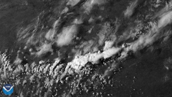
The GOES East satellite, on the evening of April 12, 2021, viewed a supercell thunderstorm bubble up in central Texas, part of several severe thunderstorms that produced hailstones up to the size of a grapefruit. The so-called “gorilla” hail (term coined by storm chaser Reed Timmer) damaged multiple vehicles with dents and destroyed windshields. Through using the Advanced Baseline Imager’s high-resolution visible imagery, we can see the above-anvil cirrus plume that is the hallmark of severe thunderstorms.
The National Weather Service received dozens of reports of large hail from the thunderstorms over north-central Texas. The hail was not only remarkable for its size, but also for the fact that it reportedly accumulated up to three inches on the ground in Llano, Texas. Last week, similar weather in east Texas produced large hailstones and high winds, causing damage to trees and power lines in the area.
The GOES East geostationary satellite, also known as GOES-16, keeps watch over most of North America, including the continental United States and Mexico, as well as Central and South America, the Caribbean, and the Atlantic Ocean to the west coast of Africa. The satellite's high-resolution imagery provides optimal viewing of severe weather events, including thunderstorms, tropical storms, and hurricanes.